1
16
Geography
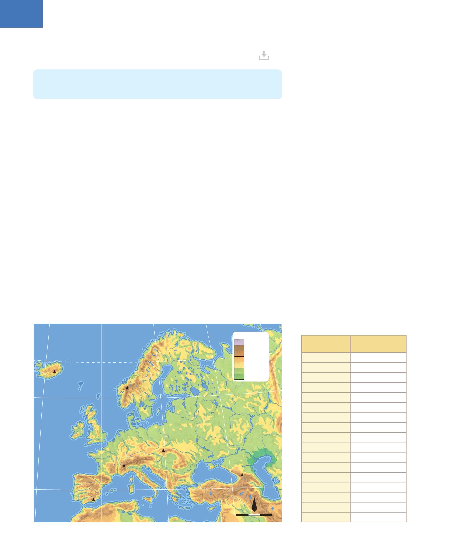
3. THE NATURAL ENVIRONMENT OF EUROPE
3.1. The relief and waters
The European continent has two very different regions of relief and hydrography.
❚
Eastern Europe
extends between the Carpathians and the Urals from west to east,
the Arctic Ocean to the north, and the Caspian Sea, the Caucasus (with the highest
peak in Europe, mount Elruz at 5 633 m) and the Black Sea to the south. It is a great
plain, extending to the north of Germany and France and its rivers are long and
voluminous: the
Ural
and the
Volga
rivers flow into the Caspian Sea; the
Don
, the
Dnieper
and the
Dniester
flow into the Black Sea; and the
Vistula
and the
Oder
flow into the Black Sea. There are also great lakes such as
Ladoga
, Onega, Ilmen, and
Peipus in Russia, and thousands of glacial lakes in Finland.
❚
Central and Western Europe
is a much more rugged
1
region, with many mountain
ranges and numerous, but shorter, rivers. In the north, are the
Scandinavian Alps
with abundant glaciers,
fiords
2
, and the Grampian Mountains (in Great Britain). In
the centre, are the mountain ranges of the
Alps
(with Mount Blanc at 4807 m), the
Carpathians
, the Vosges, the Ardennes, the Jura, the Black Forest, and the Central
Massif in France. In the south, are the Spanish mountain ranges (the Pyrenees,
Cantábrica, Ibérica, Central, Bética), the
Apennines
, the
Dinaric Alps
, the
Balkan
and the
Rhodope
. The most important rivers are the Danube, which flows into the
Black Sea; the Oder, Elba,
Rhine
, Seine,
Loire
, Garonne and
Thames
which flow into
the Atlantic (along with the Miño, Duero, Tajo, Guadiana and Guadalquivir). The Ebro,
Rhone
,
Po
, Tiber and Maritza all flow into the Mediterranean Sea. There are also
large lakes such as the
Balaton
(Hungary),
Vanern
(Sweden),
Leman
(Switzerland and
France) and Garda (Italy).
Europe is the second smallest continent in the world, after Oceania. It is separated from
Asia by the Ural Mountains, the Caucasus Mountains and the Caspian Sea. To the west
is the Atlantic Ocean and to the south is the Mediterranean Sea.
1
rugged:
rough, irregular surface
2
fiord:
narrow entrance to the sea
formed by the flooding of an excavated
or partially carved valley by the action of
glaciers
Mulhacén
3 479
Mont Blanc
4 807
Gerlachovsky
2 655
Elbrus
5 633
Glittertind
2 469
Hvannadalshnukur
2 110
Balearic
Islands
Corsica
Sardinia
Sicilia
Malta
Crete
British
Isles
Great
Britain
Ireland
Iceland
Faroe
Islands
Shetland
Islands
Hébridas
Islands
Mediterranean Sea
W
h
i
t
e
S
e
a
A
d
r
i
a
t
i
c
S
e
a
C
a
s
p
i
a
n
S
e
a
B
a
l
t
i
c
S
e
a
North
Sea
Norwegian
Sea
Barents Sea
Black Sea
Aegean
Sea
Ionian
Sea
A R C T I C O C E A N
AT L A N T I C
O C E A N
Tajo
Ebro
Po
Danube
Dniester
Loire
Thames
Rhine
Elbe
Oder
Vistula
Dnieper
Don
Ural
Volga
Pechora
Lake Vättern
Lake Vänern
Lake Onega
Lake Ladoga
Lake Peipus
Iberian
Pen.
Italian Pen.
Balkan
Pen.
Jutland
Pen.
Scandinavian Pen.
Kola Pen.
North Cape
C. Fisterra
Strait of Gibraltar
E
n
g
l
i
s
h
C
h
a
n
n
e
l
C
A
R
P
A
T
H
I
A
N
S
S
.
B
é
t
i
c
o
s
A
p
e
n
n
i
n
e
s
A
l
p
s
D
i
n
a
r
i
c
French
Massif Central
U
R
A
L
M
O
U
N
T
A
I
N
S
S
C
A
N
D
I
N
A
V
I
A
N
M
T
S
C
A
U
C
A
S
U
S
A
L
P
S
P
Y
R
E
N
E
E
S
Greenwich meridian
Arctic Circle
G
u
l
f
o
f
B
o
t
n
i
a
G
r
e
a
t
E
u
r
o
p
e
a
n
P
l
a
i
n
Caspian
Depression
G
u
l
f
o
f
F
i
n
l
a
n
d
Lake Ilmen
Lake Balatón
Lake Leman
Rhône
Azov
Sea
Height (m )
4000
2000-4000
1000-2000
500-1000
200-500
0-200
0
2 500 km
0
1:133 904 000
N
40º N
60º N
20º E
0º
20º O
40º E
60º E
Rivers and
lakes
Length/
Surface area
Volga
3692 km
Danube
2860 km
Ural
2428 km
Dnieper
2287 km
Don
1870 km
Dniester
1411 km
Rhine
1326 km
Vistula
1047 km
Tajo
1038 km
Loira
1012 km
Rhone
815 km
Po
682 km
Thames
350 km
Lake Ladoga
18130 km
2
Lake Vanern
5545 km
2
Lake Balaton
592 km
2
Lake Leman
581 km
2


