1
22
Geography
6. THE NATURAL ENVIRONMENT OF ASIA
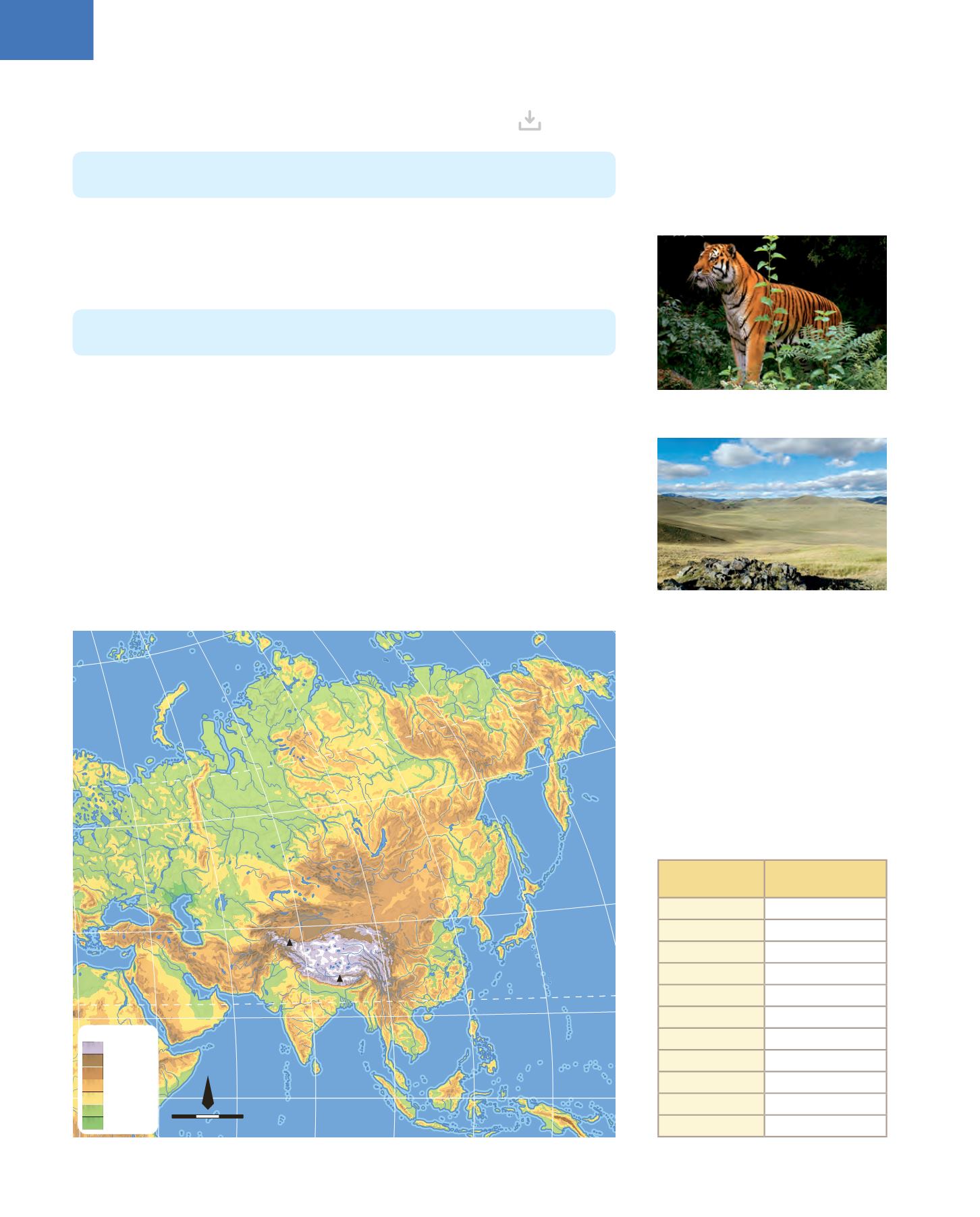
6.1. The relief and waters
The seas and oceans that bound this continent are the Arctic Ocean to the north, the Pacific
Ocean to the east, the Indian Ocean to the south and the Mediterranean Sea to the west.
The Altai and Tien Shan mountains separate China from the Siberian plains and Mongolia.
There are also many high plateaus, such as those in
Tibet
, Iran, and Anatolia (Turkey).
Asia has numerous peninsulas (
Anatolia
,
Arabian
,
Hindustan
,
Malacca
,
Korea
, and
Kamchatka
); many islands (
Borneo
,
Sumatra
,
Java
,
Ceylon
,
Formosa
and
Taiwan
, the
western half of the island of
New
Guinea and
Cyprus
) and archipelagos (the
Philippines
and
Japan
).
The Asian rivers are very long: the
Obi
, the
Yenisei
and the
Lena
flow into the Arctic
Ocean; the
Amur
, the
Yellow River
, the
Chang Jiang
or Yangtze and the
Mekong
river
flow into the Pacific Ocean; and the
Ganges
, the
Indo
, the
Euphrates
and the
Tigris
flow
into the Indian Ocean. Some important lakes are the
Caspian Sea
(the largest lake in the
world), Lake
Baikal
in Siberia, the
Aral Sea
(currently dried up due to human intervention)
and the
Dead Sea
, which is the lowest point on Earth (416 m below sea level).
Asia is the largest continent (44.5 million km
2
) and has the highest mountains in the
world. The
Ural
mountains separate Asia from Europe.
The
Himalayas
are the main mountain range on the Asian continent. The peak of
Mount Everest
, at 8848 m, is the highest point in the world.
Celebes
Sea of
Okhotsk
I N D I A N
O C E A N
Sea of
Japan
East Siberian Sea
Laptev Sea
Kara
Sea
Black Sea
Red Sea
Aragian
Sea
Caspian Sea
South
China
Sea
Eastern
China Sea
Philippine
Sea
M
e
d
i
t
e
r
r
a
n
e
a
n
East
China Sea
S
e
a
P A C I F I C
O C E A N
A R C T I C
O C E A N
Sri Lanka
Sumatra
Borneo
Java
Philippine
archipelago
Formosa
Japanese
Archipelago
Kuril
Islands
Cyprus
Maldivas
islands
Nueva
Guinea
Kamchatka
Pen.
Korean
Pen.
Indochinese
Pen.
Hindustan
Pen.
Arabian
Pen.
Malay
Pen.
Anatolian
Pen.
Western
Siberian Plain
Central
Siberian Plateau
Meseta de
Kazajstán
Chinese
grand
prairie
Mongolian
Plateau
Pamir
Plateau
Iranian
Plateau
Tibetan Plateau
S
i
b
e
r
i
a
n
P
l
a
i
n
N
o
r
t
h
e
r
n
Bay of
Bengal
Persian
Gulf
G
u
l
f
o
f
A
d
e
n
Euphrates
Tigris
Indus
Ganges
Mekong
Chang Jiang
Amur
Yenisey
Obi
Lena
H
w
a
n
g
H
o
Lake Baikal
Lake Balkhash
Dead
Sea
Aral
Sea
K2
8 611
Everest
8 848
Thar
Desert
G
o
b
i
D
e
s
e
r
t
Z
a
g
r
o
s
M
t
s
T
i
a
n
S
h
a
n
K
u
n
l
u
n
H
I
M
A
L
A
Y
A
S
K
o
l
y
m
a
M
t
s
C
h
e
r
s
k
y
M
t
s
V
e
r
k
h
o
y
a
n
s
k
M
t
s
New Siberia
Islands
Taymyr
Peninsula
Equator
Tropic of Cancer
Arctic Circle
40º E
60º E
80º E
100º E
120º E
140º E
160º E
180º
20º N
40º N
60º N
Manchuria
Plain
M
o
n
t
e
s
A
l
t
a
i
U
R
A
L
M
O
U
N
T
A
I
N
S
C
A
U
C
A
S
U
S
Height (m)
4000
2000-4000
1000-2000
500-1000
200-500
0-200
0
2 500 km
0
1:147 310 000
N
Rivers and
lakes
Length/
surface area
Chang Jiang
6300 km
Huang Ho
5464 km
Lena
4400 km
Mekong
4350 km
Yenisei
4093 km
Obi
3650 km
Indo
2900 km
Amur
2874 km
Ganges
2510 km
Caspian Sea
386400 km
2
Lake Baikal
31500 km
2
Siberian steppe
Siberian tiger


